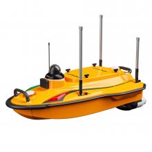
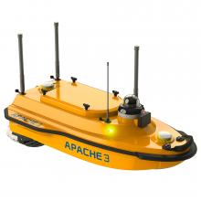
CHCNAV's Apache 4 Pro is a powerful, autonomous USV (Unmanned Surface Vehicle) for precise hydrographic surveys. With its shallow draft, stable position in the water, and highly accurate GNSS+IMU navigation, it is ideal for surveying tasks in rivers, canals, reservoirs, and areas that are difficult or dangerous for manned boats to access. It is lighter than its predecessor and features a more robust hull design. Thanks to its one-piece construction, it offers 60% greater collision resistance while weighing 30% less.
The Apache 4 Pro is specially designed for current and discharge measurements. Adaptive navigation ensures that the USV maintains its route precisely – even in changing currents or turbulence. Floating positioning enables stable holding at start and end points, which significantly increases the accuracy of the measurement data.
The Apache 4 Pro features a new generation of anti-collision and drive protection mechanisms, such as optional “high-density” wood protection net technology, which reduces the risk of the motor becoming entangled by 70%.
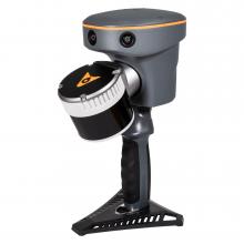
Thanks to the central instrument mount, various sensors can be integrated, including multibeam echo sounders and other hydrological measuring devices. The Pro version is also optimized for integration with the HQ-400 multibeam echo sounder.
With a payload capacity of up to 50kg, the system is highly versatile – from traditional surveying to applications in flood monitoring or port infrastructure. It offers improved straight-line navigation and can navigate and hover precisely even in strong currents (4 m/s) and at high speeds (6 m/s) (position stability better than 0.5m).
The Apache 4 Pro supports common ADCP models such as RiverStar, M9, RTDP 1200, RiverPro, and RiverRay. Positioning, power supply, data transfer, and waterproofing are fully integrated – plug-and-play for efficient workflows.
The Apache 4 Pro now uses highly sensitive anti-interference transducers with vibration damping technology. This results in a shallower “body zoom” depth (only 10 cm), better resolution (3 mm), and a signal-to-noise ratio improved by 6 dB.The Android-based remote control provides a reliable connection via 4G and 2.4 GHz. In combination with the CHCNAV EasySail app, you get live data, video feedback, route planning, and mission management directly on the display.
Product characteristics
- Dimensions (LxWxH): 1200x750x400mm
- Material: Highly durable and reinforced carbon fiber
- Weight: 13kg
- Maximum load capacity: 50kg
- Wave and wind protection: Wind level 3 and wave level 2
- Hull construction: Triple-hull vessel
- GNSS: Internal GNSS dual antenna
- Water protection: IP67
- Draft: 8.6cm (unloaded)
- Indicator light: Two-color (positioning and differential signal)
- Camera: 360° omnidirectional video
- ADCP compatibility: Compatible with RiverStar, M9, RiverPro, RiverRay, RioGrande, and other ADCPs
- Available instruments: ADCP, integrated compact multibeam echo sounder, side-scan sonar, water quality monitor, sampling container
- Distance and range for obstacle avoidance: 0.2–40m (H: 112°, V: 14°)
- Propeller type: Brushless DC motor
- Directional control: Turning without control motor
- Motor power: 800W
- Maximum motor speed: 7200 ± 5% RPM
- Li-ion battery capacity: 32.4V, 23.1Ah
- Battery life: 9.8 hours at 1.5m/s (1 battery set, expandable)
- Power supply: Support for single/double symmetrical batteries
- Battery charging time: 3h
- Maximum speed of the boat: 6.5m/s
- Communication:
- Data communication: Standard 4G and remote control
- Remote control range: 1km (remote); unlimited (4G)
- SIM card slot: Nano SIM
- Reserved interface: 2x RJ45 ports, 2x serial RS232 ports
- Navigation mode: Manual or autopilot
- Data storage: Local (multi-channel) & remote control
- Software: Easysail
- Positioning:
- Satellite system: BDS B1I/B2I /B3I、GPS L1C/A/L2P(Y)/L2C/L5, Galileo E1/E5a/E5b, GLONASS L1/L2, QZSS L1/L2/L5
- Single Point Position (RMS): Horizontal: 1.5m; Vertical: 2.5m
- DGNSS position accuracy: Horizontal: 0.4m + 1ppm; Vertical: 0.8m + 1ppm
- RTK position accuracy: Horizontal: ±8mm + 1ppm; Vertical: ±15mm + 1ppm
- Radio protocols: Satel 3AS, CHC, TT450, Transparent
- Course accuracy: 0.1 ⁰ @1m baseline
- Inertial navigation stability: 6 ⁰/ h (accuracy drop 1m after 20 s)
- IMU update rate: 200 Hz
- D270 Single beam echo sounder:
- Data type: CHCGD, NMEA SDDPT/SDDBT, original waveform
- Sound range: 0.1m to 200m
- Sound accuracy: ±0.01m + 0.1% x D (D is the water Depth)
- Resolution: 0.01m
- Maximum sampling rate: 30 Hz
- Frequency: 200 kHz
- Beam angle: 6.2° ± 1°
- Sound velocity adjustment range: 1400–1700 m/s
- Integrated water temperature sensor: -55 °C to +100 °C, real-time correction of sound velocity
Delivery content
- 1x APACHE4 USV fuselage (including D270 & camera)
- 4x LiPo battery (23100mAh 32.4V)
- 2x lithium battery charger for 23100 mAh
- 1x APACHE4 case
- 1x remote control (EC10)
- 1x EC10 packaging box
- 1x EC10 accessory package
- 2x RC & WIFI antenna
- 1x 4G antenna
- 1x high-frequency radio antenna
- 1x ESC debugger
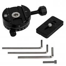
- 1 set of screws for HQ-400 assembly
- 1x lean tube holder
- 1x UPS screw set
- 1 set of UPS standard accessory pack (RS)
- 4x stainless steel thumb screws M6*14